
This is about recommended motorbike routes in Nan province, North Thailand. For more information about Nan province have a look at Destination Travel Guide Nan. Nan province is one of Thailand's last remote provinces with stunning mountains, waterfalls and National Parks. And paradise for motorbike riding. And because Nan province is so remote the roads are not busy and relatively safe to ride.
Nan province is famous for the Bo Klua Loop (like the Pai & Mae Hong Son Loop in Chiang Mai), but of course there is much more to be riding in Nan province. Most people are riding their own motorbike or rent one in Bangkok, Chiang Mai or Chiang Rai. But in Nan town are nowadays also a few shops renting Motorbikes or Scooters. For more information have a look at Motorbike Rental Shops. As for scooters it is recommended not to rent a "small scooter" but at least 150cc. And of course ALWAYS wear a good helmet, jacket, gloves and good shoes. Also be aware that scooters are by law motorbikes and that you will need a motorbike driver-license for it (check your travel insurance).
For a personal touch of help or for creating your own personal tailor-made holiday together with a local travel specialist, feel free to send an email to Your Personal Travel Butler The Little Elephant (free of charge).
Warning
Be aware that after rain the roads can be slippery. Especially in the mountains. But also in the early morning with fog. And in the raining season there could be landslides blocking roads or some parts of road could be washed away.Bicycling
Nan is a great area for bicycling, both on road as off road. The routes here mentioned are on-road and of course all routes could also be done by bicycle, but i.m.o. you should adjust the routes a bit to avoid using the main roads (like route 101) as that is really not safe for bicycling. I have some idea about that, so if you like more information about that send me and email.When to go?
Best to be done at the end of the raining season or during the cool season, from September to February. But of course you could ride the all year long. But in the raining season be aware that due to the rain there could be landslides and in the mountains roads could be blocked or gone.Accommodation
In Nan town are many hotels, guesthouses, resorts and homestays. But also in places like Bo Klua, Na Noi, Pua, Thung Chang, Chiang Klang or Mae Charim are also many hotels and homestay's. When staying in Pua, come and enjoy the slow life of Pua at Non Na Pua Homestay.Road Condition
Road condition can change suddenly in the raining season in the mountains.
- Route 101 all the way from Phrae to Huai Kon is nowadays mostly a 4 lane highway but they are working on the last remaining parts that are still 2 lane.
- Route 1148 from Tha Wang Pha to Chiang Kham is at some places steep and has a lot of curvs but is for 90% in good condition.
- Route 1256 from Pua to Bo Klua is full of curves, some steep parts and the road surface is not always good (gravel / put-holes).
1. The Bo Klua Loop

This route starts from Nan town via the mountains to Santisuk via route 1169. And from there via the stunning route 1081 to Bo Klua. Along route 1081 you will be passing Base 29 Coffee Shop and Rai Sut Mung Pho Farm. Bo Klua is a small village famous for its Ancient Salt Pits. Next to the salt pits, right along the small river, is a nice coffee shop also. In the main street are a few restaurants. From Bo Klua this route takes you via route 1256 to Pua. This is a part of 50 km full of curves, ups & downs. A lovely road to ride, you will be passing Viewpoint 1715, Chum Phu Kha Shrine and the HQ of Doi Phu Kha National Park. Just before Pua you are passing a small coffee shop called Adonis Coffee that doubles as car/motorbike-wash, som-tam shop and you can also drink a beer. Of course they also serve good coffee (cold and hot). Pua is a bigger town with restaurants, a few pubs and many hotels. Actually a great place to stay. From Pua this route takes you via route 1081 again in direction of Santisuk. Along the route you could make a stop at Sila Phet Waterfall. In Santisuk again just take route 1169 back to Nan.
Instead of route 1081 & 1169 from Pua to Nan you could also take route 101 passing Tha Wang Pha and Nan Art Gallery.
1.1 Extended Bo Klua Scenic Routes
You could do the Bo Klua Loop but taking a more scenic route via route 1257, the so called Scenic Bo Klua Loop. And you could even extend that loop by also taking route 1333 (passing Phu Fa Royal Project), the so called Extended Scenic Bo Klua Loop. Be aware that on some maps route 1333 has another number. Be also aware that the road condition of route 1257 & route 1333 could be with pot holes at some places. It is the road less travelled.

2. The Huai Kon Loop
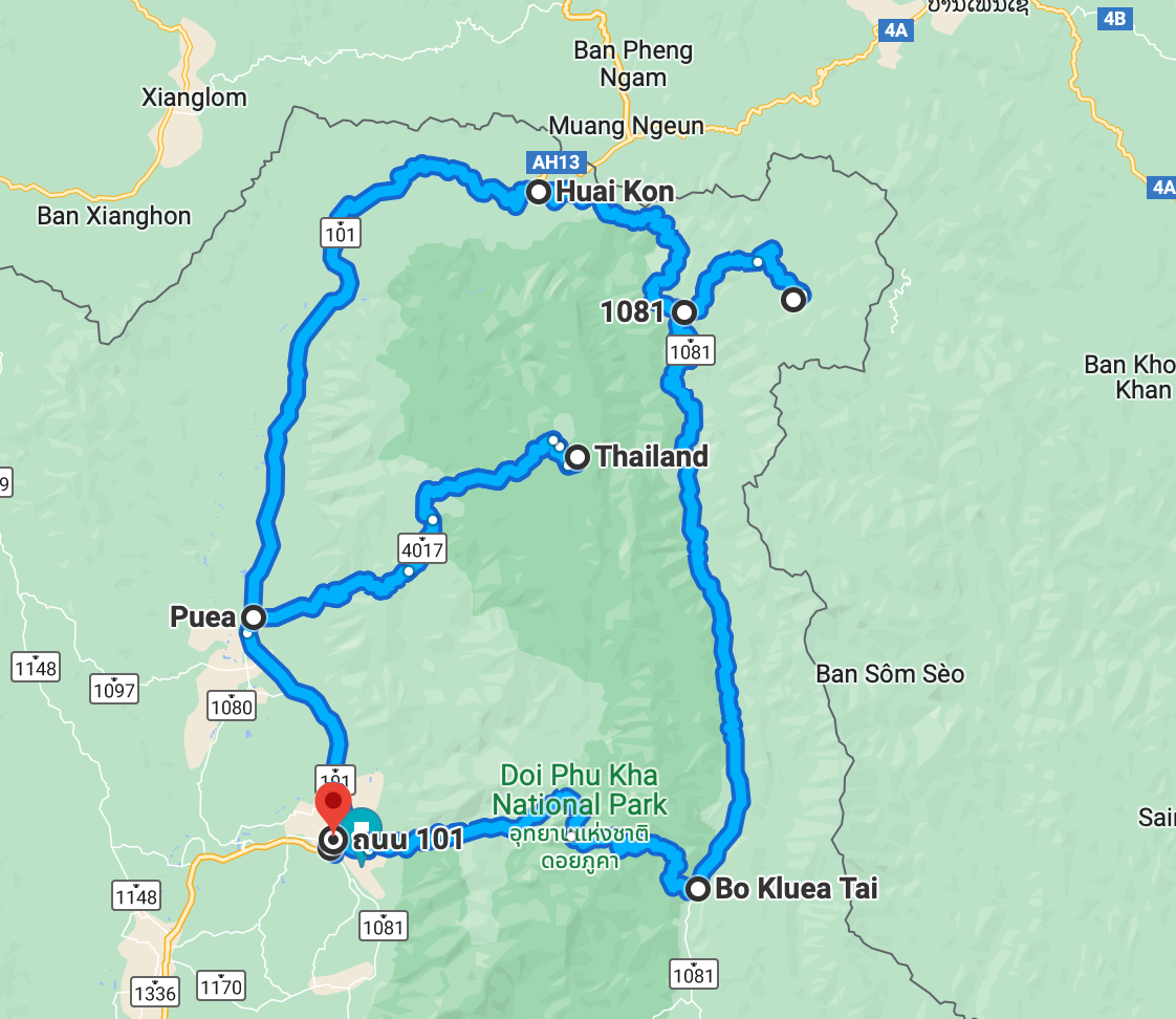
This loop could start in Pua, Bo Klua, Thung Chang or Chiang Klang. And while doing this loop you could make 2 side trips, first to Phu Phayak (Communist Memorial) and later to Manipruek (Hmong hill-tribe village and stunning view points). As extension from Bo Klua to Pua via Phu Phayak, Huai Kon and Maniruek this loop is 260 km. Doing almost the same route but then from Pua this loop is 310 km. Without the side trips to Phu Phayak and Manipruek the loop is 110 km shorter. Stunning route but do not forget that some road parts are in bad (put-holed) condition. But you can do it with any road bike or scooter.
If your route begins in Pua then first take route 1256 from Pua to Bo Klua, start early and have a stunning view at Viewpoint 1715. In Bo Klua go left in direction of Ban Sapan and Huai Kon with route 1081. Just follow the main road, there are not much side-roads. After about 50 km you will come at a kind of T-section in a curve. To the right you could make an extension to Phu Phayak. Continuing route 1081 another 30 km to an intersection with route 101. Just follow the main road for another 50 km and you will be passing an intersection with signs to the left for Manipruek. Continuing another 20 km and you will end-up in Pua. In Pua are some restaurants, hotels/guesthouses and pub's.
2.1. Side trip to Phu Payak Communist Memorial
About 50 km north of Bo Klua is a sign to the right to Phu Phayak where you will find the famous Communist Memorial. It is a small and winding road but currently in 2021 in good condition until you get to the village where the road becomes very narrow, sometimes very steep and in bad condition. And be aware that the Communist Memorial Museum is not always open (actually mostly closed). |
| Link to Google Maps |
2.2. Side trip to the International Thai-Lao Border Crossing Huai Kon
Not on the map but a few km north of the intersection between route 1081 and route 101 is the International Border between Thailand and Laos, en-route to Hongsa and Luang Prabang. But since 2018 motorbikes are not allowed to enter Laos without a licensed Lao tour. At the village of Huai Kon you can find the Remains of Communist Battlefield & Museum. It is at a small army base and there is always someone to open the door for you.2.3. Side trip to Manipruek
Between Thung Chang and Chiang Klang there is a road going to the left going to Manipruek, a Hmong & Yao hill-tribe village high in the mountains of Doi Phu Kha. In the old days an area of poppy production, nowadays it are all vegetables. Besides the local hill-tribe villages there are also stunning viewpoints. Be aware that the road might be in bad condition. You also will be passing the entrance to Thailands deepest cave (no guide, light or any supervision).3. The Mae Charim Loop

This trip starts again on the east-side of the main bridge crossing the Nan River. Just follow the main road straight ahead and follow route 1168. After a few km there is a round-about, here you go to the left and continue to follow route 1168. After about 40 km you get at a Y-section. To the left route 1168 continues as side-trip. But you continue straight ahead (or you could call right) on route 1243. After about 20 km there is a road to the left going to Mae Charim National Park. You go straight ahead until Man Muap. There at a T-section route 1243 continues to the left, but you take a right to route 1162. Just keep on following route 1162 until Wiang Sa. At a T-section you will hit route 1026, take a right in direction of Nan. At the intersection with traffic lights take a left until another intersection with traffic lights at route 101. Then take a right and continue another 20 km to Nan. Be aware that the side-trip extension will take about 1 to 2 hours extra at least. For more information see Mae Charim.
3.1 Side trip to Ban Rom Klao
A nice side-trip in the Mae Charim Loop is route 1259 to Rom Klao (thanks Steve). It is a dead-end road of about 35 km to a village high in the mountains, the road is brand new has a lot of curves and stunning views.
4. To Nanthaburi National Park & Ban Sop Khun

Not a loop this time and the begin via route 101 is a bit boring (although you could make some side trips here like taking route 1169, 1081 and 1170) but the rest of the route is stunning. End destination is a hill-tribe village on the border of Nan province and Phayao province. The route is 90 km one-way. From Nan town take route 101 in direction of Pua. Then in Tha Wang Pha take a left for route 1148 in direction of Chiang Rai. Then after about 2 km turn left (look for signs for Nanthaburi National Park) and start following route 4022 thru a small village. After that just keep following route 4022 although there are some weird curves in the road with also other roads connecting. The National Park is a few km from the main road and the last 1 km could be a bit of a gravel road. Again a few km from the viewpoint at the HQ of the National Park is Doi Wao, even higher as the HQ viewpoint. The road going there is a steep gravel road. If you are passing the National Park route 4022 will continue to a small village in the mountains at the border of Nan province and Phayao province. The real road stops here, but for the off-road diehards there is a dirt road going to Phayao province.
5. The Na Noi Loop

From Nan town follow route 101 to Wiang Sa and from there route 1026 to Na Noi. From Na Noi you can make a side-trip to Si Nan National Park (stunning view points) via route 1083. From Na Noi continue via route 1026 to Nathong (have a drink at 10.000 miles Bikers Cafe). In the village go straight ahead an start following route 4010 in direction of Phrae. Take route 1217 and 1216 to Khun Sathan National Park. Keep on following route 1216 back to Na Noi.
6. Route from Nan to Chiang Rai

Not the shortest route from Nan town to Chiang Rai, but a stunning route to ride, 238 km in total. From Nan you go north and follow route 101 for about 40 km to Tha Wang Pha. There we take a left to route 1148. Just keep on following the main road. Do not forget at Song Kwae to go to the left, otherwise you end up in Laos. Until Chiang Kham it is just following route 1148 thru the mountains. There is not much along the road here, only a few coffee shops & restaurants at Phu Lanka what is a famous viewpoint. From Chiang Kham I prefer to take the short-cut to route 1020 (not really shorter in time or distance but less traffic). Just keep on following route 1020 in direction of Chiang Rai. You will be passing a kind of by-pass road and then you will be crossing route 1 and ride into Chiang Rai.
6.1. Side trip Ban Charoen
As this route has some more options to ride, following are some extra's from this route. First of all while you are riding route 1148 to or from Chiang Rai you could make a "small" side trip into the mountains to the Yao / Mien hill-tribe village Ban San Charoen, famous for its Royal Projects coffee plantations (that were originally poppy plantations). It is only 20 km but small and steep roads, with of course stunning views. Nearby are also an hot spring (but not worth to go there) and a waterfall (but difficult to get there). From Ban San Charoen you could go off road to the mountain ridge between Nan province and Phayao province (great place for camping). In good weather this track is done by 4WD car.
6.2. Alternative route to route 1148
Secondly there is a partly alternative way to go to Chiang Rai. Instead of taking route 1148 from Tha Wang Pha you can take route 1097 from Chiang Klang. This route meets route 1148 near Song Kwae. This is a very scenic route with a lot of curves. You will be passing Tad Man Waterfall and 2 hill-tribe villages.
6.3. Side trip to Song Kwae Border Market
Thirdly at Song Kwae you could make a side trip to Song Kwae Thai-Lao Border Market (actaully the Ban Mai Chai Daen Thai-Lao Border Market). On Google maps it looks easy, just follow route 1279 but in reality the route is mostly without signs, very small roads thru villages. And be aware that the market is only on Sunday in the very early morning.
7. Route from Nan to Phayao

Shown here is the shortest route from Nan to Phayao, only 149 km. But one could also take a more scenic route and going north around the mountains on the east of Phayao. The trip starts on the west side of town on route 1091. Just follow the main road for about 65 km and continue route 1091 until Chiang Muan where is a T-section. Route 1091 continues to the right. After about 10 km take a left for route 1251 (for the scenic route keep on following route 1091 north). Keep on following route 1251 (not ride into Doi Phu Nang National Park) thru some villages. At the T-intersection with route 1021 go left and follow route 1021 until route 1. Take a right at route 1 and after a few km take a left into Phayo.
8. Route from Nan to Loei

- Be aware that Google Maps shows a connecting road between route 1081 and route 1243, but this is at least partly a single dirt track (but more likely for 90%).
- Instead of going to Dan Sai from Na Heao you could also continu along the Thai-Lao border in direction of Phu Ruea and there go to route 21.
9. Nan East-South-West Loop

Be aware the the route especially at the west is a adventure route and might not be suite-able for all riders or all motorbikes.
10. Alternative for route 101 to Chiang Klang

Be aware that this is a sight-seeing route to avoid at some places riding on the boring route 101. With this route you are passing Nan Riverside Ary Gallery and Wat Nong Bua. And with a little detour just before Chiang Klang you could visit some small rapids in the Nan River. Near Wat Nong Bua is a nice restaurant along the Nan River called Khing Pho Restaurant. In Chiang Klang you could have a lunch at the restaurant of Sangthong Resort.
11. Alternative Route from Phrae to Nan

This looks like and easy & short "only" 240 km, but it is almost all curves in the mountains and some road parts might be in low-quality condition.
12. Short trip from Pua to Ban Sakad

This trip starts in Pua town and with only 20 km it is a very short trip, but a nice trip to ride when staying in Pua town. The village is at about 1.000m above sea-level (so 800m higher as Pua) and the village is build on the slopes of the mountains of Doi Phu Kha. This route starts at the PTT Gasoline station along route 101 and ends at a coffee shop in the beginning of Ban Sakad, from there you can ride and/or walk in the village. The tarmac on the road ends at the end of the village, but for off-road riders here the fun starts as you can ride from here to Manipruek or to route 1256 to Bo Klua.